Aldeburgh is a town in Suffolk located on the Alde river. Its name, Alde Burgh means "old fort" although this, along with much of the Tudor town, has now been lost to the sea. In the 16th century, Aldeburgh was a leading port, and had a flourishing ship-building industry. Sir Francis Drakes's ships Greyhound and Pelican (later renamed Golden Hind) were both built in Aldeburgh. The flag ship of the Virginia Company, the Sea Venture is believed to have been built there in 1608. When the river Alde silted up and was unable to accommodate larger ships, the area went into decline. Aldeburgh survived principally as a fishing village until the nineteenth century, when it became popular as a seaside resort. Much of its distinctive and whimsical architecture derives from this period. The river is now home to a flourishing yacht club.
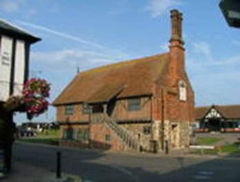 The Moot Hall is a 16th C timber-framed building which has been used for council meetings for over 400
years. It also houses the local museum, displaying items of local interest such as artefacts depicting life
in Aldeburgh, the emphasis being on the fishing industry and the part played by the lifeboat and it’s
crews.
The Moot Hall is a 16th C timber-framed building which has been used for council meetings for over 400
years. It also houses the local museum, displaying items of local interest such as artefacts depicting life
in Aldeburgh, the emphasis being on the fishing industry and the part played by the lifeboat and it’s
crews. Outside the town, the Snape Maltings is the venue for a well-known classical music festival every June. Benjamin Britten who died in Aldebugh in 1976 was one of the founders of the Aldeburgh Festival started in 1948. Aldeburgh is also famous for its Fish and Chip shop. Owned and run by the Cooney family since the 1970’s, it has been described in The Times as "Possibly the finest on the East Coast".
Aldeburgh was the first British town to select a female mayor,Elizabeth Garrett Anderson, in 1908 and also has a unique quatrefoil Martello Tower. Near the Martello Tower at Slaughden Quay are the barely-visible remains of the fishing smack "Ionia". It had become stuck in the treacherous mud of the River Alde, and was then used as a houseboat. In 1974 it was burnt, as it had become too unsafe. Amongst many other landmarks, most notably the Moot Hall, this too was featured in the Orlando (The Marmalade Cat) stories written by Kathleen Hale, who spent holidays in the town. Further south of the beach is Orford Ness.
 Just north of Aldeburgh are a couple of notable landmarks, The House in The Clouds at Thorpeness and the
Sizewell nuclear power stations, plus of course the now infamous Scallop on the beach itself.
Just north of Aldeburgh are a couple of notable landmarks, The House in The Clouds at Thorpeness and the
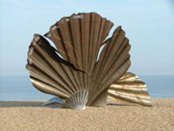
Sizewell nuclear power stations, plus of course the now infamous Scallop on the beach itself.The Scallop is dedicated to Benjamin Britten, who used to walk along the beach in the afternoons. Created from stainless steel by Suffolk-based artist Maggi Hambling, it stands four metres high, and was unveiled in November 2003. The piece is made up of two interlocking scallop shells, each broken, the upright shell being pierced with the words: "I hear those voices that will not be drowned";, which are taken from Britten's opera Peter Grimes. The sculpture is meant to be enjoyed both visually and tactilely, and people are encouraged to sit on it and watch the sea, but has been the topic of much controversy in the local area. Many people consider that it is inappropriate for a man made object to spoil a beautiful natural setting. It has been attacked with graffiti and paint on a number of occasions, and there have been petitions to have it removed.
Moot Hall - Open daily from 12:00-17:00 in June and July, entrance costs Ł1.
Felixstowe
A village has stood on the site since before the Norman conquest, eventually becoming a lynchpin in England's defence, as proved when in 1667 Dutch soldiers landed and failed to capture Landguard Fort ;. The town only became a major port in 1886. In addition to shipping, tourism increased, and a pier was constructed in 1905, sadly due to be demolished soon. Indeed, during the late Victorian period (after circa 1880) it became a fashionable resort.
A museum telling the story of Felixstowe, with a reference library, historic maps, photo archive and 14 rooms of artefacts from Roman finds, the Martello Towers, military social and domestic history through two world wars and into the new Millennium is managed by volunteers from the Felixstowe History and Museum Society. It is located in the old submarine mining establishment building at Landguard Point, between the Fort and Port and is open on Sundays, Bank Holidays and Wednesdays during the summer.
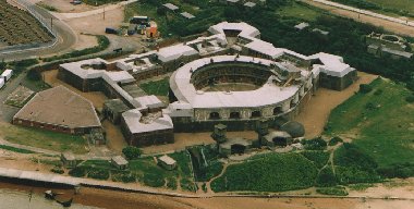 The Fort has a long and rich history. Originally built at the behest of Henry the Eighth it is the only
fort in England to have repelled a full scale invasion attempt. This was in 1667 when Captain Nathaniel
Darell and 500 men defeated Admiral de Ruyter's Dutch force on 2nd July (Darell day is still celebrated).
Since then the Fort has seen many changes during its time under military control up to 1956, when the army
finally marched out. What remains now are parts of the walls and casemate rooms within, dating from the
Fort of 1744 and later changes made during Queen Victoria's reign.
The Fort has a long and rich history. Originally built at the behest of Henry the Eighth it is the only
fort in England to have repelled a full scale invasion attempt. This was in 1667 when Captain Nathaniel
Darell and 500 men defeated Admiral de Ruyter's Dutch force on 2nd July (Darell day is still celebrated).
Since then the Fort has seen many changes during its time under military control up to 1956, when the army
finally marched out. What remains now are parts of the walls and casemate rooms within, dating from the
Fort of 1744 and later changes made during Queen Victoria's reign.During the nineteenth century Victorian engineers made massive improvements to the Fort, which included the construction of a curved seven casemated battery facing the river. Beneath the casemates and gun positions are the magazines, a labyrinth of passageways, shell, powder and cartridge stores. In some places the hoists for raising ammunition to the guns are still in situ. A large curved barrack and office section was built inside the Fort, creating an inner keep.
South of the Fort is Right Battery, built in 1901, this is now within a bird sanctuary and can be visited by prior arrangement. In collaboration with English Heritage the Landguard Fort Trust has taken over the running and management of the Fort since the autumn of 1998.
During the Second World War the majority of the pier, at the time one of the longest in the country and complete with its own train, was purposely demolished by Royal Engineers to prevent it being used as an easy landing point for enemy troops. Unfortunately after the war the damage was never repaired and the pier never regained its original length. By the late 1990s the pier had been neglected so badly that it was deemed to be unsafe and closed to the public.
The beach railway station itself was demolished in 2004 despite a storm of protest from many local people keen on saving the 137 year-old historical building which the council had branded as 'unsafe'. The station was originally opened in 1877 and was used continuously until 1959, after which it was the site of a small printers for many years until its demolition.
 Felixstowe has pebbly beach extending from the port at Languard Fort where there is a nature reserve and
bird observatory, to Felixstowe Ferry, an old fishing hamlet on the River Deben. A promenade runs the
length of the beach with traditional beach huts and various seaside shops.
Felixstowe has pebbly beach extending from the port at Languard Fort where there is a nature reserve and
bird observatory, to Felixstowe Ferry, an old fishing hamlet on the River Deben. A promenade runs the
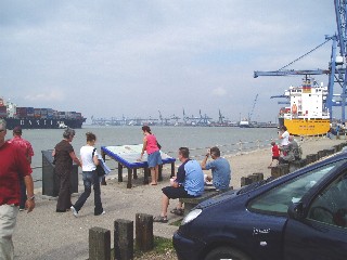
length of the beach with traditional beach huts and various seaside shops.Today Felixstowe is one of Britain's top three ports, Europe's fourth busiest and in 2002 it was ranked 20th in the world. The Landguard Peninsula attracts on average 700,000 visitors a year, and a high proportion of those trips are to the John Bradfield Viewing Area to see vessels come in and out. As part of the Port’s plans to develop the southern part of the Port, the Viewing Area will be expanded, with more room for car parking and buses. A visitors' centre will be built with interactive features and displays, and a dedicated berth added for the Felixstowe-Harwich foot ferry.
Languard Fort - Open daily from June to September 10 am - 6 pm. Last admissions 5 pm, - entrance costs Ł3.00.
Framlingham
Framlingham is an unspoilt market town in East Suffolk. It is of Anglo-Saxon origin and is mentioned in the Domesday Book. It was once referred to as 'Frimley Framlingham' by locals as a term of greater endearment. 'Fram' is today a more common name, however, and is used by most of Suffolk rather than the whole name. In 2006, 'Country Life' magazine voted Framlingham the number 1 place to live in the Country.
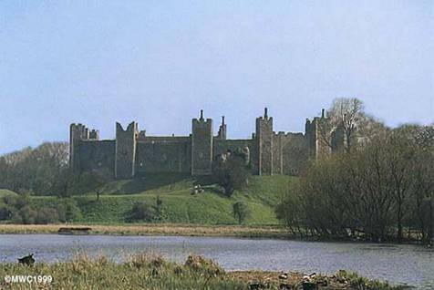
One of it’s famous landmarks is Framlingham Castle. Although the castle is largely ruined, walkways make sections of the walls accessible. In common with many other buildings in Suffolk, the main walls of the castle are faced with flint. It is unusual, especially for a castle of the time, because it had no keep or central stronghold, but merely a strong cutain wall defended by projecting towers which enclosed the domestic buildings.
This Castle is said to have been founded by Raedwald, one of the most powerful kings of the East Angles, between A.D. 599 and 624. It belonged to Edmund, one of the Saxon monarchs of East Anglia, who fled to the castle after the invasion of the Danes. He was then driven from the castle, caught and put to death, being bound to a tree and shot with arrows in A.D. 870. His body, after many years, was removed to a place called Bederics-gueord, now Bury St. Edmunds. The castle remained in the hands of the Danes for fifty years, when they were brought under the obedience of the Saxons. William the Conqueror and his son Rufus retained the Castle in their own possession, but the third son of William, Henry I, then granted it, with the Manor of Framlingham, to Roger Bigod, 1st Earl of Norfolk.. It became the seat of the Earls of Norfolk, and continued in this family till Roger Bigod, 5th Earl of Norfolk, the last of the race, and a man more turbulent than any of his predecessors, died without issue and his estate was compelled to resign it to Edward I.
Since then it was passed through further Dukes of Norfolk, the Mowbrays and the Howards, (many of whose Tombs and monuments are housed in the famous St Michael’s Church nearby). In 1553 the castle was given by King Edward VI to his sister Mary Tudor (one of its most famous residents) and she stayed there while waiting her sucession to the crown, which hung in the balance. Her colours flew over the gateway and thousands of her supporters camped around the castle till the Earl of Arundel arrived to inform her she was Queen.
In Elizabeth’s reign the castle was used as a prison for Priests who defied the Church of England, before being returned to the Howards in 1613. The days of Glory and pomp at Framlingham were over and the Howards preferred their new house at Kenninghall in Norfolk. The castle was leased and fell into decay and finally sold to Robert Hitchen in 1635. When he died his will ordered the castle to be pulled down except for it's outer walls and a poorhouse was to be built inside. He was also responsible for the building of the Almshouses in Framlingham, which still survive today. The castle was leased to various groups and societies for meetings, after the poorhouse was redundant. It was then owned by Pembroke college. It passed into the care of the state in 1913 and was later given to English Heritage, who run the castle today.
Framlingham Castle - Open daily from 10:00-18:00, entrance costs Ł2.95.
Orford
Orford is a small town in Suffolk which was of some importance as a port and fishing village in the Middle Ages. It still has a fine mediaeval castle built by Henry II , to dominate the River Ore, consolidate royal power in the region, and keep a close eye on Hugh Bigod, the 1st Earl of Norfolk whose family owned nearby Framlingham castle. The well preserved Norman keep stands among the earth-covered remains of the outer fortifications.
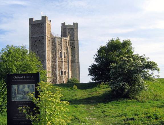
Construction work at Orford Castle began in 1165 according to plans still held at the Public Records Office in London. The marshes nearby were drained turning the village of Orford into a sheltered port. The castle cost Ł1413 to build, contrasting with royal revenue of Ł10,000 a year. The design of the castle was unique. The 90 foot high central tower was circular in cross-section with three rectangular towers built into the structure. This was surrounded by a curtain wall with flanking towers and a fortified gatehouse. These outerworks were quarried for building material in the post-mediaeval period. Only the tower remains but it is one of the best-preserved examples of Plantagenet castle architecture. The castle also featured a suite for use by the king on completion in 1173.
In 1177, Henry's oldest child Henry the young King rebelled over control of lands allotted to him. The 1 st Earl of Norfolk supported the rebellion leading to Orford Castle becoming heavily garrisoned. Upon the collapse of the rebellion, Henry ordered the confiscation of Framlingham Castle. After Henry’s death in 1189, the castle was captured by Prince Louis of France who invaded England in 1216 at the invitation of the English barons who were disillusioned by King John.
In 1280 under the rule of Edward I, Orford Castle was granted out and eventually sold. This marked the beginning of the end, as the estuary of the River Alde silted up and trade declined, reducing the importance of the castle as the centre of local government. In 1930 the remains of the castle were presented to the Orford Town Trust who passed it to the guardianship of the British government in 1962. The keep of the castle is the only visible part of the structure remaining intact and it is now maintained by English Heritage who run regular tours of the building. Orford Castle is regarded as one of the best preserved castles of the period remaining.
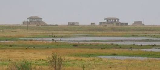 The main geographical feature in the area is Orford Ness, a 15km long, wide spit at the mouth of the Ore,
which has variously been used as an airstrip testing facility and nature sanctuary over the years. It is
reached by ferry from Orford's quay and in the early 1970s, was the site of a very powerful radar station
as part of the Cold War defences against low flying attacking aircraft.
The main geographical feature in the area is Orford Ness, a 15km long, wide spit at the mouth of the Ore,
which has variously been used as an airstrip testing facility and nature sanctuary over the years. It is
reached by ferry from Orford's quay and in the early 1970s, was the site of a very powerful radar station
as part of the Cold War defences against low flying attacking aircraft.Described by a BBC documentary as 'half wilderness, half military junkyard', it is a shingle spit, linked to the mainland at Aldeburgh and stretching along the coast to Orford. It is divided from the mainland by the River Alde, and was formed by longshore drift from material further north along the coast. The peninsula was formerly administered by the Ministry of Defence, which conducted secret military tests during both world wars. The Atomic Weapons Research Establishment had a base on the site, and is believed to have developed the firing mechanisms for nuclear devices there. Many of the buildings from this time remain clearly visible from the quay at Orford, including the distinctive-looking 'pagodas’' which were designed to collapse in the event of an accidental explosion. There is also a transmitting station on the peninsula, which uses the former Cobra Mist experimental over-the-horizon radar site to send medium wave broadcasts across the North Sea to mainland Europe.
Orford Ness is now owned by the National Trust and is open to the public under the name "Orford Ness National Nature Reserve", though some buildings are closed off because of their advanced state of disrepair. Owing to its military history, its stark appearance and the fact that it was closed to the public for many decades, several apocryphal stories have circulated about Orford Ness. The best-known is the suggestion that Nazi troops attempted to invade England and actually disembarked at the tip of the peninsula, before being repelled with a wall of fire
Extracts from an eye-witness account by Ronald Ashford, a Local Defence Volunteer born in 1922, tells of the incident one night late in August 1940.